Tuesday, November 12, 2013

Thuan An beach

Thuan An beach is situated near by Thuan An mouth, where Huong River runs to Tam Giang lagoon and then to the sea...


In the beginning of the 19th century, King Minh Mang named the place as Thuan An, assigned to build Tran Hai frontier post for the defence of the Capital.

Far from Hue 15 km, only 15 minutes by car, tourists are able to reach the beach. Plenty small boats, junks drift up an down the river in the left of the route, and on the right there are houses, temples, pagodas, rice field, and gardens successively spread out....


Thuan An is a very enjoyable place for all tourists after a full day to visit Citadel, mausoleums, pagodas, and Hue scenery... Thuan An is also the place, where Hue people gather to enjoy the fresh air and sea-bathing in summer time. Intensive activities of the beach lasts from April to September, while Hue temperature being fairly hot. Sometimes, tourists are very crowded, and there are not enough places for their camping.


Besides sea bathing, tourists are able to visit Thai Duong temple, where Thai Duong Goddess is very esteemed by villagers or visit the temple devoted to the whale, the sacred animal of the local people

Thien Cam Beach

Considered as a “Heaven’s Lute”, Thien Cam is a rhythmically beautiful beach in central Vietnam, attracting thousands of tourist turns annually.
BriefingsIf you are wondering about a summer vacation place, Thien Cam beach (Cam Xuyen, Ha Tinh Province) should be on top of your choices. The reason is that not only does it have a wild and pristine beauty with pure environment being good for your health, but an interesting magical legendary as well.

Located approximately 20 kilometers from  the town of Ha Tinh province, Thien Cam has been well known and praised as a romantic and pristine beach recently. The beach is bound by Thien Cam Mountain, which makes a beautiful landscape of the harmony of sea and mountain. Thien Cam beach’s beauty is also added by Yen Lac Pagoda where tourists can explore the architecture style of the 13th century and contemplate the famous old picture of “The Kings of Hell’s Ten Palaces”. It has been told from generation to generation that here used to be a favour destination of the first King of Vietnam - Hung King where he could relax on the mountain and listen to the rhythmical sound of ocean.
Thien Cam beach lies in a region of monsoon tropical climate with two distinctive seasons, the hot and cold seasons. The average temperature is 22oC-25oC, and the annual average rainfall is above 2,200mm or 3,500mm in some places and 1,719 sunny hours a year.
Seen from above
When being seen from above, Thien Cam beach looks like a huge bow, stretching around 3 kilometers from Thien Cam Mount foot to Đầu Voi Mount (Elephant Head Mount). These together with Cum Nay (Great Mount) and Cum Con (Small Mount) make up huge musical instrument keys scattered along the pure Ky La stream, which curves round the hillside to flow into the sea.
Thien Cam Beach derived its interesting name from a very special legendary, which tells that when passing by the zone, King Hung took a rest at Ky La mountain (the former name of Thien Cam) where he heard the waves of the sea whispering soft and low and the pine singing in the wind. That made him imagine it like a melody created by a Heaven’s Lute.  With such a great feeling, he renamed Ky La into a magic name of “Heaven’s Lute” or Thien Cam, which remains till today.
Let’s take a round trip
Thien Cam beach brings you a great opportunity of a healthy and romantic vacation. Coming here, you will surely be attracted by the pristine beauty attaching to low mountains. You can enjoy cool and purely blue sea. You can play with its small waves sweeping into and out of the  silk-like fine sand banks. Even you can relax yourself by lying or walking on the fine and clean sand. Or you can go boat sailing or shipping. Only in Thien Cam could tourists hear admirable sounds of sea winds, waves, howling tree leaves striking mountain cliffs, which create sweet melodies . All these make you  feel you were in a fantastic land with refreshing moments.

After satisfying with such comfortable entertainment,  you can take a ship to Boc Island, which has a marvelous rock banks turning to the sea. Waves strike the rock banks all day long, making an ideal bathing site with rippling waves.
Leaving Boc Island, the ship now brings you to Tien seaside resort (Bãi  tắm  Tiên) at Tuong Mount foot. Among several small beaches, Tien seaside resort is the prettiest one. It is loaded with rock caves and sand banks, cross-valley full of fresh and salty water creating the tide line. Scattered along the rock side, it is bird trapper, lobster, and sea-chesnut catcher.
Back to the beach, you can go up to Thien Cam mountain and enjoy the melody of the Heaven’s Lute that Hung King used to feel. Then sliding down to the mountain foot and walking for couples of minutes, you can integrate into the religious world of Yen Lac Pagoda with the beauty of the 13th century architecture style.
Last but not least, it seems to be a good news for those who adore foods of sea. Thien Cam is the place of numerous delicious sea foods that are appreciated as the gifts of the Nature. Staying here, you can taste  lobster, squid, Cu Ky bird, Nhuong fish source, and so forth, which are of uniqueness in Ha Tinh.
In central Vietnam in general and Ha Tinh province in particular, Thien Cam beach is one amongst the finest seaside. As both preserved and improved, the number of tourists to Thien Cam is on a gradual rise every year.

Nha Rong Wharf

Nha Rong Wharf is a cultural site with special relics in Ho Chi Minh City, where late President Ho Chi Minh left to seek ways to save the nation over 100 years ago.


On June 5, 1911, the patriotic young man Nguyen Tat Thanh left the country on the ship, Admiral Latouche Treville, to begin his quest for salvation. Many changes have taken place over the past 100 years but Nha Rong Wharf still exists and ideals of the young man who later became the great leader of Vietnam are still shining along with the nation.

Nha Rong Wharf - Sai Gon’s trading port on the Saigon Vietnam River – was built in 1863 by French colonialists. The building was a combination of western and eastern architecture. 


Nha Rong is the name that Vietnamese used to call the office of France’s Messageries Maritimes Company. This magnificent building was built in 1863, four years after the French seized Saigon. It has original and strange architecture. Its roof has the elegant beauty of the roof of a Chinese pagoda with two dragons competing for a fireball. As there are two dragons on the roof, Vietnamese call the building Nha Rong.

Nha Rong is located at the three-way intersection of the Saigon River and Ben Nghe Canal. On the far side of the canal, there was a rice field on a high area. At that time, there was no bridge over the canal, so people went to Nha Rong by boat. More than 20 years later, the Messageries iron bridge was built to connect Adran Street, now Ho Tung Mau Street, with the far side of the canal.
Messageries Maritimes was a big sea transport company and was established in 1851. It was headquartered in Marseilles and had shipping routes to America, Africa, the Middle East and Asia. Many ships of the company were named after Vietnam’s geographical places such as Annam, Tourane, Sontay, and Haiphong. Nha Rong Wharf was the stopover for ships going from Marseilles to Hong Kong and Yokohama. 


Many postcards were printed with the images of ships and wharfs used by Messageries Maritimes and there were paintings of the company’s ships in storms. Nha Rong appeared in many postcards for decades. Later it was printed on the Vietnamese 50,000-dong banknote. Together with Ben Thanh Market, Nha Rong is one of the two symbols of Ho Chi Minh City.
After the French colonial were defeated in 1954, the wharf was managed by the South Vietnam government which repaired the roofs of the two houses and replaced the old dragons with two new ones that dace outwards. 

After Unification Day, the building became a historical relic and memorial area for President Ho Chi Minh.

To mark the 10th death anniversary of Uncle Ho on September 2, 1979, Nha Rong Wharf welcomed visitors to an exhibition on “President Ho Chi Minh’s career for salvation”. The Ho Chi Minh City People’s Committee decided to turn the “President Ho Chi Minh Memorial” into the “Ho Chi Minh Museum” on September 20, 1982.


The museum collects, preserves, displays and disseminates information about President Ho Chi Minh’s life and revolutionary career as well as his love for the southern people. 

The Ho Chi Minh Museum in Ho Chi Minh City currently has more than 11,000 documents and items and 3,300 books on President Ho Chi Minh.

Nha Rong Wharf is a great location for tourists Vietnam travel who want a unique experience.

Thursday, November 7, 2013

Cu Chi Tunnels

Consisting of many underground tunnels with the total length of more than 200km, Cu Chi Tunnels are known nationwide as the base where the Vietnamese planned their operations of the Tet Offensive in 1968. Today, parts of the tunnel have been modified to serve visitors in Vietnam travel. Coming there, visitors can understand more about the prolonged resistance war of the Vietnamese people and also of the persistent and clever character of the Vietnamese nation.
Cu Chi Tunnels are located approximately 70km northwest of Ho Chi Minh City centre in Cu Chi Rural District. They consist of more than 200km of underground tunnels. The main axis system has many branches connecting to underground hideouts, shelters, and entrances to other tunnels.
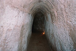
Cu Chi District is known nationwide as the base where the Vietnamese mounted their operations of the Tet Offensive in 1968.The tunnels are between 0.5 to 1m wide, just enough space for a person to walk along by bending or dragging. However, parts of the tunnels have been modified to accommodate visitors. The upper soil layer is between 3 to 4m thick and can support the weight of a 50-ton tank and the damage of light cannons and bombs. The underground network provided sleeping quarters, meeting rooms, hospitals, and other social rooms. Visiting the Cu Chi Tunnels, tourists joining tours in Vietnam are provided with a better understanding of the prolonged resistance war of the Vietnamese people and also of the persistent and clever character of the Vietnamese nation. 
For a place that's physically invisible, the Cu Chi Tunnels have sure carved themselves a celebrated niche in the history of guerilla warfare. Its celebrated and unseen geography straddles "all of it underground" something which the Americans eventually found as much to their embarrassment as to their detriment. They were dug, before the American War, in the late 1940s, as a peasant-army response to a more mobile and ruthless French occupation. The plan was simple: take the resistance briefly to the enemy and then, literally, vanish. 
First the French, then the Americans were baffled as to where they melted to, presuming, that it was somewhere under cover of the night in the Cuu Long (Mekong) Delta. But the answer lay in the sprawling city under their feet - miles and miles of tunnels. In the gap between French occupation and the arrival of the Americans the tunnels fell largely into disrepair, but the area's thick natural earth kept them intact and maintained by nature. In turn it became not just a place of hasty retreat or of refuge, but, in the words of one military historian, "an underground land of steel, home to the depth of hatred and the incommutability of the people." It became, against the Americans and under their noses, a resistance base and the headquarters of the southern Vietnam Liberation Forces. The linked threat from the Viet Cong - the armed forces of the National Liberation Front of South Vietnam - against the southern city forced the unwitting Americans to select Cu Chi as the best site for a massive supply base - smack on top of the then 25-year old tunnel network. Even sporadic and American's grudgingly had to later admit, daring attacks on the new base, failed for months to indicate where the attackers were coming from and, importantly, where they were retreating to. It was only when captives and defectors talked that it became slightly more clear.
 But still the entries, exits, and even the sheer scale of the tunnels weren't even guessed at. Chemicals, smoke-outs, razing by fire, and bulldozing of whole areas, pinpointed only a few of the well-hidden tunnels and their entrances. The emergence of the Tunnel Rats, a detachment of southern Vietnamese working with Americans small enough to fit in the tunnels, could only guess at the sheer scale of Cu Chi. By the time peace had come, little of the complex, and its infrastructure of schools, dormitories, hospitals, and miles of tunnels, had been uncovered. Now, in peace, only some of it is uncovered as a much-visited part of the southern tourist trail. Many of the tunnels are expanded replicas, to avoid any claustrophobia they would induce in tourists. The wells that provided the vital drinking water are still active, producing clear and clean water to the three-tiered system of tunnels that sustained life. A detailed map is almost impossible, for security reasons if nothing else: an innate sense of direction guided the tunnellers and those who lived in them.
Some routes linked to local rivers, including the Saigon River, their top soil firm enough to take construction and the movement of heavy machinery by American tanks, the middle tier from mortar attacks, and the lower, 8-10m down was impregnable. A series of hidden, and sometimes booby-trapped, doors connected the routes, down through a system of narrow, often unlit and invented tunnels. At one point American troops brought in a well-trained squad of 3000 sniffer dogs, but the German Shepherds were too bulky to navigate the courses. One legend has it that the dogs were deterred by Vietnamese using American soap to throw them off their scent, but more usually pepper and chilly spray was laid at entrances, often hidden in mounds disguised as molehills, to throw them off. But the Americans were never passive about the tunnels, despite being unaware of their sheer complexity. Large-scale raiding operations used tanks, artillery and air raids, water was pumped through known tunnels, and engineers laid toxic gas. But one American commander's report at the time said: "It's impossible to destroy the tunnels because they are too deep and extremely tortuous."
 Today the halls that showed propagandas films, housed educational meetings and schooled Vietnamese in warfare are largely intact. So too are the kitchens where visitors in Vietnam tourism can dine on steamed manioc, pressed rice with sesame and salt, a popular meal during the war, as they are assailed with true stories of how life went on as near-normal, much of the time. Ancestors were worshipped there, teaching was well-timetabled, poultry was raised and even couples trusted, fell in love, were wed, and honeymooned there. But visitors have it easier: those re-constructed tunnels give the flavour of the tunnels but not the claustrophobia and the sacrifice of the estimated 18,000 who served their silent and unseen war there with only around one-third surviving, the rest casualties of American assaults, snakes, rats and insects.
 Now the unseen and undeclared No Man's Land is undergoing a revival, saluted as a Relic of National History and Culture with its Halls of Tradition displaying pictures and exhibits. The nearby Ben Duoc-Cu Chi War Memorial, where the reproduced tunnels have been built, stands as an-above ground salute to a hidden war.
If you are in or planning to Ho Chi Minh City, you should visit Cu Chi Tunnels where you can be provided with better understanding of Vietnam during the War as well as persistent and clever character of Vietnamese nation.